Stuðlagil ended up being one of the highlights of my Ring Road trip — but it’s also one of the spots where the difference between a good visit and a frustrating one comes down to a few small decisions you make before you arrive. Which side you go to, when you go, and where you sleep the night before all matter more than the guides let on.
Here’s what I’d tell anyone planning to visit.
Two sides, two very different experiences 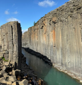
Stuðlagil has two access points and they offer completely different experiences.
The west side is the easier one. You park close, walk a short distance, and look at the canyon from a viewing platform above. New platforms and metal stairs leading down to the river have been added here, which makes the canyon accessible to people who can’t manage a longer hike. That’s genuinely valuable — not everyone is in a position to walk for two hours. But the platforms are a significant intervention in what used to be a wild spot, and the construction has been controversial locally. It’s worth being aware of both sides of that.
The east side is where the real experience is. You park, walk along a gravel track that runs above the river, and end up right inside the canyon next to the basalt columns and the turquoise water. This is the angle you’ve seen in every photo of Stuðlagil — and it only happens from the east.
If I had to choose one side, I’d choose east without hesitation. The west is fine for a quick stop on the way in or out, but it’s not why people travel here.
How long the east side hike actually takes
From the lower parking lot near the white bridge it’s roughly 4 km one way to the canyon viewpoint, so plan for about 1.5 to 2 hours each way at a normal pace. The trail isn’t difficult — mostly flat gravel along the river — but it’s longer than people expect and the underestimation catches a lot of visitors out.
There’s also an upper parking lot called Klaustursel that you can reach by driving across the bridge and continuing on the rough gravel road for about another kilometre. From there the walk drops to roughly 30 to 45 minutes. The road up isn’t great but it’s drivable in a regular car if you take it slowly. I managed it without a 4×4.
So you have a real choice: park at the lower lot and turn it into a proper hike, or take the bumpy track further up and cut your walking time in half.
When to go to avoid the crowds
This is the single biggest piece of advice I’d give: arrive early or arrive late.
I slept at the campsite on the west side and drove around to the east the next morning. By the time the first tour buses started rolling in around 10 or 11 am, I’d had the canyon almost to myself for over an hour. By midday it gets busy in a way that genuinely changes the experience — narrow viewpoints with people queuing for photos.
The other option is the opposite end of the day. The Icelandic summer means it stays light until late, so coming in the evening after the tour buses have left works just as well. A few people I saw at the canyon had clearly planned it this way and they had the place to themselves too.
If you arrive in the middle of the day in July or August, you’ll see Stuðlagil — but you won’t really experience it.
Where to sleep the night before
The campsite right next to the west side viewpoint is the obvious base. It has the essentials — toilets, showers (small fee), dishwashing area — and it’s positioned so you can do a quick evening walk to the west side viewpoint to get your bearings before the proper visit the next morning.
For me this worked well. The drive from the campsite around to the east side parking takes about 15 minutes, so I was on the trail by 7 am while most other visitors were still in Egilsstaðir or further away.
The campsite is reached via gravel Route 923 off the Ring Road. Nothing dramatic — just normal Icelandic gravel road conditions.
The parking situation and the app you’ll need
The parking costs 1.000 ISK (about €7) per vehicle and it’s paid through an app called Parka. You scan a QR code at the parking area and pay within 24 hours. The same 1.000 ISK covers both east and west side parking for the whole day, so if you’ve paid at one side, you don’t pay again at the other.
Two things to know about this:
First, mobile signal in the area can be patchy. Multiple recent visitors have reported struggling with the payment because the connection drops. Download the Parka app before you leave the Ring Road, and if the signal is weak at the parking lot, walk a bit until you have a stronger connection.
Second, the west side has paid toilets and a food truck. The east side has more limited facilities depending on which parking lot you use — a food truck sometimes operates at the upper lot in summer, but I wouldn’t count on it.
When the water is actually turquoise
This is the part that confuses a lot of visitors. The river isn’t always the bright turquoise colour you see in the photos.
From my own visit and from what other recent visitors have reported, the rough pattern looks like this:
- June and July tends to be reliably blue-turquoise — the iconic colour
- March to early July can also be a good window, though early spring can be murkier from snowmelt
- Late August into September the colour often turns grey or brown because the nearby Kárahnjúkar dam releases overflow water that carries sediment
I was lucky and the water was the postcard colour. But I’ve seen plenty of August and September photos where it looks more like a normal grey glacial river — still impressive geology, just not the same colour. If the colour matters to you, mid-June to mid-August is the safest bet.
Overcast days are actually better for photos. It reduces glare on the water and the colour comes through more vividly.
A few practical things nobody mentions
- Wear proper footwear. The trail is uneven and can be slippery in places, especially the small scramble down to the river level on the east side. Trail running shoes are fine. Flip-flops or city sneakers would be a bad idea.
- The river current is strong and the water is cold. Don’t even think about wading in.
- No facilities on the trail itself. Use the toilets before you start walking.
- The east bank trail is typically only fully accessible June to October. In winter the path can be icy and water levels are higher.
Is it worth the detour?
Stuðlagil is about 70 km from Egilsstaðir and around 20 minutes off the Ring Road on Route 923. It’s not a huge detour if you’re already in East Iceland.
If you’re trying to do the Ring Road in a tight schedule, the question is whether you’d rather rush through here in the middle of the day with the crowds, or build in an overnight nearby and do it properly. I’d genuinely recommend the second option.
It’s one of those places that rewards a bit of planning. Get there early, hike the east side, and you’ll understand why people make the detour.
This is part of my 14-day Iceland Ring Road campervan guide, which covers Stuðlagil along with every other major stop on the route — including campsites, timing notes and what to skip. You can find the full guide here.